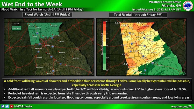
A Flood Watch remains in effect for much of north Georgia through Friday afternoon. Parts of the area have already seen over an inch of rainfall with additional amounts of 1-2″ expected through tomorrow with locally higher totals possible.
A wet end to the week is expected as a cold front brings showers and isolated thunderstorms to the area through late Friday. Rainfall totals are forecast to be 1-4 inches across much of the area, with locally higher amounts possible in far north Georgia. A Flood Watch is in effect for far north Georgia from 7 AM Thursday until 1 PM Friday, as expected rainfall may result in localized flooding concerns

FLOOD WATCH REMAINS IN EFFECT FROM 7 AM EST THIS MORNING THROUGH FRIDAY AFTERNOON…
* WHAT…Flash flooding caused by excessive rainfall continues to be possible. *
WHERE…Portions of north central Georgia, northeast Georgia and northwest Georgia, including the following counties, in north central Georgia, Cherokee, Dawson, Fannin, Forsyth, Gilmer, Hall, Lumpkin, Pickens and Union.
In northeast Georgia, Banks, Towns and White. In northwest Georgia, Bartow, Catoosa, Chattooga, Dade, Floyd, Gordon, Haralson, Murray, Paulding, Polk, Walker and Whitfield.
* WHEN…From 7 AM EST this morning through Friday afternoon.
* IMPACTS…Excessive runoff may result in flooding of rivers, creeks, streams, and other low-lying and flood-prone locations.
* ADDITIONAL DETAILS… – Areas of heavy rainfall will move across portions of north Georgia today into Friday afternoon. Rainfall totals of one to two inches with locally higher amounts up to 4 inches are expected on near saturated grounds. Localized flash flooding and quick rises on creeks and streams will be possible. – http://www.weather.gov/safety/flood


