BOTTOM LINE UP FRONT / OVERVIEW:
A very cold and potentially wintry period is beginning to take shape for parts of Georgia as we head into next week. Confidence is HIGH with the much colder conditions, but remains LOW with snow and/or ice, at this time, mainly due the high amount of uncertainty with various reliable models (also being 5+ days out still).
What we can tell you at this point is — given the below-normal cold conditions that are expected to overspread (and persist across) the entire forecast area by Monday (1/20), any “wave” or storm system that moves across the northern Gulf or Southeast Region is likely to bring a period of wintry precipitation to the area, sometime between early Tuesday (1/21) and late Thursday (1/23).
WHAT:
-
Below normal cold temperatures + potential for wintry precipitation
WHERE & WHEN:
- Anywhere in north and central Georgia, sometime from early Tuesday through late Thursday (next week).
AMOUNTS / IMPACTS:
-
Too soon to truly pinpoint this due to the uncertainty in the timing, location and duration of potential snow and/or ice.
FORECAST CONFIDENCE:
-
HIGH in the colder air arriving Sunday night into Monday
-
LOW in winter weather / precipitation type, timing, location, duration and amounts
GRAPHICS:
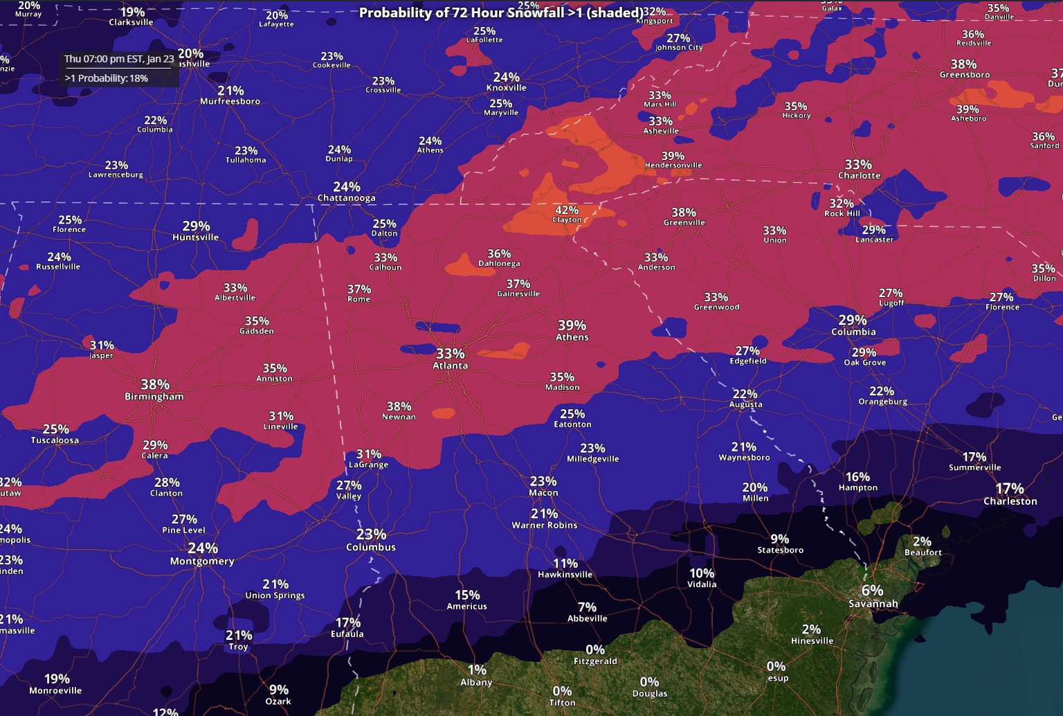
1. Probability (% chance) of seeing > 1″ of SNOW accumulation sometime between Tuesday (1/21) and Thursday (1/23):
NOTE: 30-40% this far out is fairly high.
2. Probability (% chance) of seeing > 0.10″ of ICE accumulation sometime between Tuesday (1/21) and Thursday (1/23):
NOTE: the ice potential is displaced farther south from the “better snow” area.
3. Cold Temperatures: Forecast Minimum Overnight Temperatures and Minimum Wind Chill Values (minimum Apparent Temp) for Sunday night/Monday morning through Tuesday night/Wednesday morning:
**Number of hours at or below 32F degrees (between 7PM Sunday and 7AM Wednesday – 1/19 through 1/22):
NOTE: Maximum number is 60 hours


